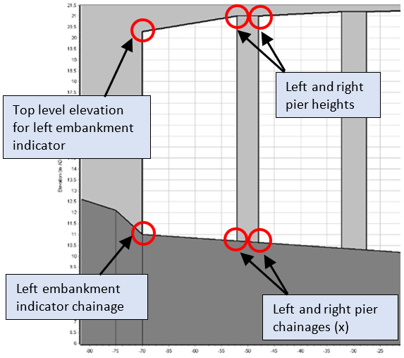
Visual Representation of Parameters for Pier Loss Bridge Unit
Parameter name | Description | Label name in data file |
|---|---|---|
No. of data points | Number of data entries describing the upstream face of the bridge cross-section. Not a data entry - solver sets this based on number of data rows defined in upstream section table. Minimum of 3 data points should be defined, i.e. a triangular section. OR can be set to zero, in which case the downstream section data will be adopted for both bridge faces (and so must be defined) The upstream bridge cross-section extends along the toe of any embankment on the left floodplain, across the channel, and along the toe of any embankment on the right flood plain. This can be thought of as the river and floodplain section prior to bridge construction | npts_us |
Cross-chainage | Cross-chainage (m or ft). Chainage is expected to be a real number and increasing | usxpi |
Elevation | Elevation of bed or flood plain (m or ft AD). Must be a real number | usypi |
Mannings n | Manning roughness coefficient. Must be a positive, real number | usrni |
Embankment indicator | Mandatory field of 1 character; only options are ‘L’ or ‘R’ to indicate left or right embankments of main channel Interface presents options “Left” and “Right” for you to select to set these indicators. The section can only have one left and one right marker. | uschmaini |
Top level | The top level represents the soffit elevation at your specified left and right embankment points (note that any top-level entries on rows that are not embankment indicators will be ignored by the solver). The top-level values should be measured using the same reference datum as the section elevation data. | ustoplev |
Parameter name | Description | Label name in data file |
|---|---|---|
No. of data points | Number of data entries describing the downstream face of the bridge cross-section. Not a data entry – solver sets this based on number of data rows defined in downstream section table. Minimum of 3 data points should be defined, i.e. a triangular section. OR can be set to zero, in which case the upstream section data will be adopted for both bridge faces (and so must be defined) The downstream bridge cross-section extends along the toe of any embankment on the left floodplain, across the channel, and along the toe of any embankment on the right flood plain. This can be thought of as the river and floodplain section prior to bridge construction | npts_ds |
Cross-chainage | Cross-chainage (m or ft). Chainage is expected to be a real number and increasing | dsxpi |
Elevation | Elevation of bed or flood plain (m or ft AD). Must be a real number | dsypi |
Mannings n | Manning roughness coefficient. Must be a positive, real number | dsrni |
Embankment indicator | Mandatory field of 1 character; only options are ‘L’ or ‘R’ to indicate left or right embankments of main channel Interface presents options “Left” and “Right” for you to select to set these indicators. The section can only have one left and one right marker. | dschmaini |
Top level | The top level represents the soffit elevation at your specified left and right embankment points (note that any top-level entries on rows that are not embankment indicators will be ignored by the solver). The top-level values should be measured using the same reference datum as the section elevation data. | dstoplev |